Subject: Western United States
Period: 1847 (dated)
Publication:
Color: Hand Color
Size:
17.5 x 10.5 inches
44.5 x 26.7 cm
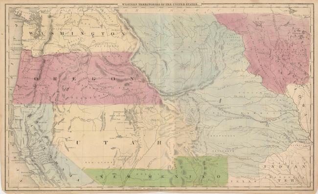
This is a great map showing the transitional boundaries of the American West. Oregon and Washington Territories are massive, stretching all the way from the Pacific to the Rocky Mountains at the Continental Divide. Oregon's southeast border meets with an extension of Texas' panhandle, which goes through the region of present day Denver. The wide Utah Territory reaches across to Texas, and the huge Nebraska Territory extends from Canada's border down to Texas and Indian Territory. Minnesota is a large territory as well, which includes a vague Dacotahs region that extends to the Missouri River. A Mormon settlement is noted on the Great Salt Lake - this is probably one of the earliest maps to note that fact, as Joseph Smith and his followers had just settled in this region in 1847. An early look at the region that incorporates much of J.W. Powell's discoveries.
References:
Condition: B+
Margins close, as issued. Map has some soiling along the edges. Hinge remnants and children's pencil markings on verso, with no show-through.