Subject: United States - Southeast
Period: 1895 (dated)
Publication:
Color: Printed Color
Size:
17 x 36.5 inches
43.2 x 92.7 cm
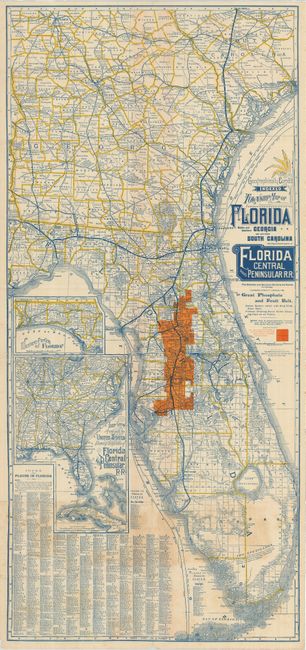
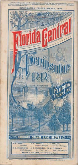
Great promotional railroad map. Title continues "The Shortest and Quickest Route to all Points in Florida. Extending Directly through the Great Phosphate and Fruit Belt." The map is beautifully printed in blue, yellows and orange. The lands of the Florida Central & Peninsular Railroad Company are highlighted in orange and include the towns of Lakeland, Dade City, St. Catherine, Wildwood, Summerfield, Silver Springs, Ocala, and Lochtoosa. The map extends north to include parts of Georgia and South Carolina to Columbia, an inset shows Western Florida. A large, separate representation is titled "South-eastern Portion of the United States showing Connections of Florida Central and Peninsula R.R." The verso contains 18 panels, each with orange printed banner for the railroad with text below describing the beauty, bounty and opportunity awaiting the "Tourist, Sportsman, Invalid, Settler and Prospectors" traveling to Florida. Self folding, with lovely pictorial cover panel printed in blue and orange. Printed by the Matthews-Northrup Company of Buffalo. A rare and desirable land promotional map and brochure that folds to 4.2" x 9".
References:
Condition: B+
A couple fold intersection splits very with minor loss. Covers with a little light foxing. Map has some light, uneven toning.