Subject: North America
Period: 1844 (dated)
Publication: Olney's School Geography
Color: Hand Color
The United States and Great Britain established in 1818 joint claim over the Oregon Territory - the region north of Spanish controlled Upper California up to the southern boundary of Russia's Alaska Territory at North latitude 54°40'. By the late 1830's this arrangement was beginning to fall apart.
In the 1840's the expansionist Democrats, including their 1844 presidential candidate, James Polk, claimed the entire region for the United States. Their expansionist desires were expressed by Polk's famous campaign slogan, "Fifty-four Forty or Fight!" The slogan also became a rally cry for Americans desiring to settle the territory. Following Polk's election, the dispute was resolved by the 1846 Treaty of Oregon, which struck a compromise that fixed the U.S./Canadian boundary at 49º North.
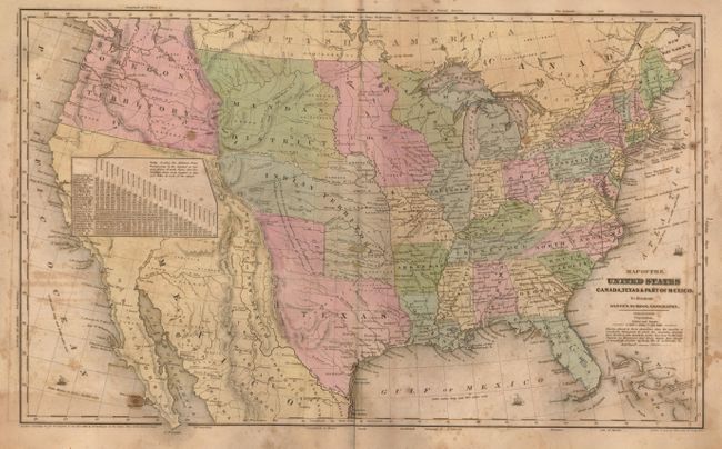
Two maps that clearly show the Independent Republic of Texas. In the first, Mexico controls California and the Southwest, which is labeled Mexico, while the Baja is called Old California. A large table of distances covers much of northern California. The huge Oregon Territory extends to the Continental Divide and well north into British America as part of the 54°50' or Fight controversy. East of Oregon is the large Mandan District that extends to an oversized Iowa at the Missouri River, that in turn extends to Wisconsin at the Mississippi River. Texas stretches to above 38° and a small region named Santa Fe or New Mexico lies to the west. The map has terrific territorial configurations and is filled with information on forts, Indian tribes, waterways and more. Copyright date of 1844 by D.R. Robinson. (17.5" x 10.5")
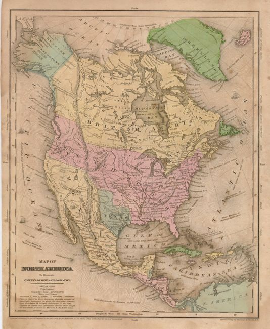
The second map also shows the Republic of Texas and the 54°40' or Fight border in the northwest. Alaska is Russian Possessions, Canada is British America and New Britain. Each country has its population listed in a box -- Texas has 500,000 and the U.S. stands at 17 million. (8.5 x 10.5") The pair.
References:
Condition: B
Both are on sound and supple paper with full margins. They also have overall foxing or offsetting.