Subject: Western Hemisphere
Period: 1652 (dated)
Publication:
Color: Hand Color
Size:
22.2 x 17.3 inches
56.4 x 43.9 cm
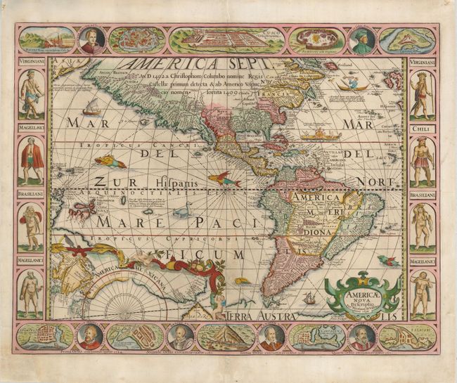
This superb map is the first single-sheet map of the Americas to include carte-a-figures borders. The border decorations were inspired by Blaeu's wall map of 1608, but the portraits of Columbus, Vespucci and the first four circumnavigators are unique. The geography is based for the most part on Hondius' map of 1606, with the exception of the unique inset that shows the Northwest Passage from the Davis Strait to the Anian Strait. The inset presents the new discoveries of Hudson and includes the legend The B. wher Hudson did winter. Other new discoveries that were added to this later state include an insular Tierra del Fuego and Staten Land and Le Maire's Strait based on the voyages of Le Maire and Schouten, and Hendrick Brouwer.
This magnificent map brings together several important figures in Dutch cartography; Petrus Kaerius (also known as Pieter van den Keere), Abraham Goos, and Claes and Nicolaus Visscher. The map was engraved by Goos and originally published in 1614 by Kaerius. The plate was then bought by the Visschers in circa 1623, updated and published from 1631 to 1652. This example is the last state with Staten Land shown as a island at the tip of South America. All states are rare.
References: Burden #182.
Condition: B+
This is a fine, sharp impression with some professional restoration of the lower left corner with a tiny bit of neatline in facsimile. A small amount of worming along the centerfold has also been expertly filled with a few lines of facsimile. Overall a very attractive example of this rare map.