Subject: North Pole
Period: 1659 (published)
Publication:
Color: Hand Color
Size:
20.5 x 16 inches
52.1 x 40.6 cm
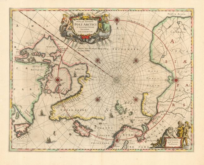
This handsome map, originally published in 1637, eventually replaced Hondius' map of the North Pole and became the prototype for many later maps including those of Blaeu. This map incorporates the discoveries made by Captain Thomas James along the southern and western shores of Hudson Bay in 1631-2. The delineation on Russia's Arctic coast is derived from the information from Willem Barents' exploration of 1596-7. Rhumb lines radiate from the North Pole and several compass roses embellish the chart. A large title cartouche, with two figures and numerous wind heads, conveniently hide the northwest coast of America. The map is further decorated with ships and a cartouche, with Jansson’s imprint, which depicts men in parkas, a polar bear and foxes. The English explorer Hugh Willoughby has a small island named after him off the coast of Lapland (Sir Hugo Willoughby's Landt). Willoughby captained an expedition of three ships to find a Northeast Passage in 1553, but two of the ships were ripped away during a storm. Willoughby and his crew from the two ships died and were found on Novaya Zemla the following year, with his journal. The third ship with his second-in-command Richard Chancellor made it to Russia. This is the third state of the map, with incomplete coastlines for Spitzberg and Nova Zemla, but with the addition of the names of Groenlandt, Americae Pars and Fretum Anian. Latin text on verso.
References: Burden #250; Kershaw 108b.
Condition: A
A near fine example with an excellent impression on thick hand laid paper with wide margins. Short split in upper centerfold is closed on verso and is only in margin.