Subject: Barbados
Period: 1674 (circa)
Publication: Histoire de l'Isle des Barbades
Color: Black & White
Size:
20 x 15 inches
50.8 x 38.1 cm
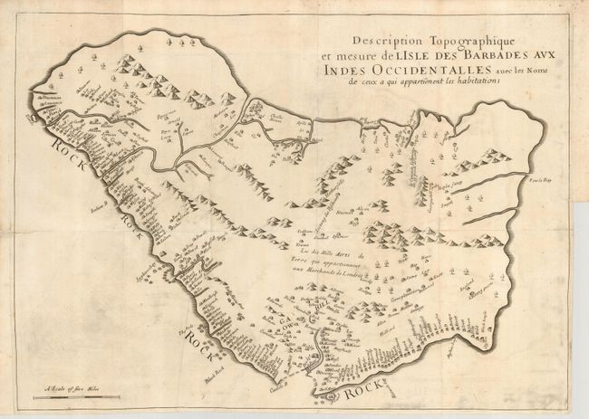
This uncommon map is the later, French edition of the earliest printed map exclusively showing the island of Barbados. Ligon based his map on information received from Captain John Swan, the island's leading surveyor of the time. The map depicts the island's outline fairly accurately, but makes it about a third longer than its correct length. The map identifies 285 plantations by the owner's name. The majority of the plantations are along the south and west coasts. Much of the embellishment found on the 1657 edition, such as vignettes of animals and people, ships, and a compass rose were not included on this map. In the middle of the map is a notation referencing the land leased by Lord Carlisle to a group of merchants after Charles I rescinded the original grant of the island to Sir William Courteen. Richard Ligon was a Royalist who escaped some of the troubled politics of England in the 1640s by spending three years in Barbados. In 1650 he returned to England where he was thrown into debtor's prison. He wrote his account and drew this map while in prison, which was originally published by Humphrey Moseley in 1657.
References:
Condition: B
A nice dark impression on a sheet with folds as issued. Close right binding side, with two short repaired tears just into the map. There are a few minor stains, light offsetting and some printer's ink residue.