Subject: Louisiana, Mississippi and Red Rivers
Period: 1764 (published)
Publication: Le Petit Atlas Maritime
Color: Black & White
Size:
13.8 x 8.5 inches
35.1 x 21.6 cm
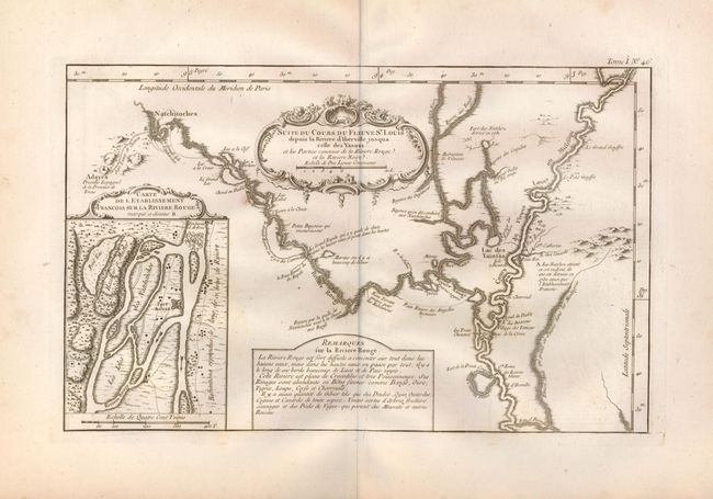
This strongly engraved copper-plate map details the course of the Red and Mississippi rivers in today's Louisiana. Covers the Red River from Natchitoches to its confluence with the Mississippi. The Mississippi is detailed from the Iberville River (now Iberville Bayou) north to its junction with the Yazoo (Yasous) River. The Red River is the central focus of the chart which includes details of the Black (Noire) River. This map is one of the first offering details of this region, which was important owing to its position between French-controlled Louisiana and Spanish Texas. The map locates the Adayes Presidio Espagnol de la Province de Tecas (Presidio Nuestra Señora del Pilar de los Adaes). Filled with other details including the location of the French controlled Fort Natchez, which had been destroyed by Natchez Indians during an uprising in 1729. With a large inset at lower left that details the vicinity of Fort St. Jean at what became Natchitoches. It shows the southern end of the blockade known as "The Red River raft," here called Embaras d'Arbres. This natural dam extended upstream for nearly 100 miles. The effort to clear this great hindrance to trade led to a frustrating 70-year long effort that was finally realized in 1900. A very nice example of this desirable map.
References: Mickwitz & Miekkavaara #10:I [46]; Phillips (A) #638, Tooley (MCC-96) #865.
Condition: B+
Dark impression on full sheet with water mark and full margins. A hint of toning or foxing in two places else very good.