Subject: Louisiana, New Orleans
Period: 1884 (circa)
Publication:
Color: Black & White
Size:
37 x 27 inches
94 x 68.6 cm
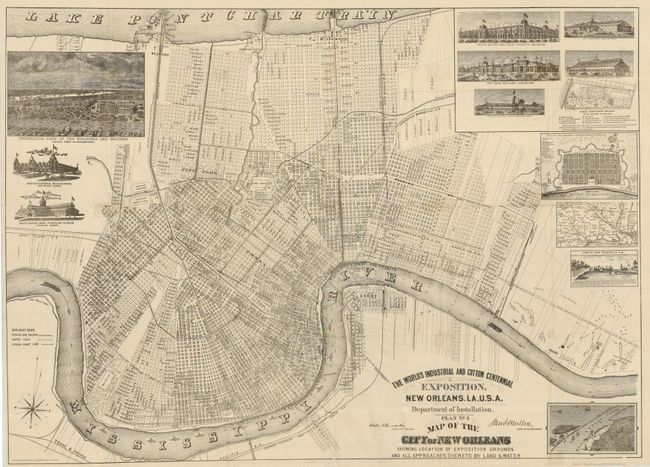
A very uncommon and detailed map shows the entire city of New Orleans from Lake Ponchartrain to the Mississippi, naming individual streets, buildings, parks, fairgrounds, railroads, docks, and a few property owners along the Mississippi. The Cotton Centennial was held in New Orleans in winter of 1884 to celebrate 100 years since the first export of cotton from the region in 1784. It was filled with exhibits from states, territories and many countries. The map is decorated with numerous insets and views including: Perspective View of the Buildings and Grounds, Mexican National Headquarters, Grand Rapids (Mich.) Furniture Pavilion, United States and State Exhibits, The Main Building, Agricultural Hall, Art Gallery, Factories and Mills, The Grounds Plans, Plan of New Orleans in 1770, View of New Orleans in 1719, and an untitled bird's-eye view of the South Pass. Lithograph by Southern Litho Co. 38 Natchez St., N.O. A scarce issue.
References:
Condition: B
The map folds and is lithographed on very thin paper with 5.5" splits at sides, 3" split at center, and intersectional fold splits repaired on verso with archival tape. A couple short tears at the margins just into the map, otherwise bright and clean.