Catalog Archive
Auction 122, Lot 167

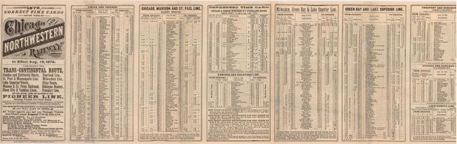
"New Map of the Chicago and North-Western Railway and its Connections", Railroad Companies, (Various)

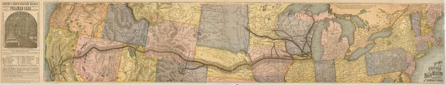
Subject: Northern United States

Period: 1876 (dated)

Publication:

Color: Printed Color

Size:
35 x 7.5 inches
88.9 x 19.1 cm
Download High Resolution Image
(or just click on image to launch the Zoom viewer)

Colorful railroad map of the northern tier of the U.S. extends from coast-to-coast. The map details the route and stations for the Chicago and North-Western Railway. The left panel on the map side is a fine engraving of the interior of an elegant Pullman Car with the pricing between major stops. On verso are extensive timetables plus a marketing panel. Dated August 19, 1876. Printed by Rand McNally & Co, Chicago.

References:

Condition: B

Tape repairs on some panel folds and tiny chip out of extreme edge of map.

Estimate: $80 - $100

Sold for: $140

Closed on 12/5/2007

Archived