Subject: World
Period: 1630 (dated)
Publication: Gerardi Mercatoris et I. Hondii Atlas…
Color: Hand Color
Size:
21.5 x 15 inches
54.6 x 38.1 cm
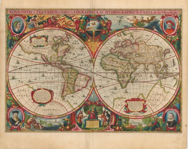
Henricus Hondius created this splendid baroque-style world map when he updated the Mercator Atlas in response to competition from the Blaeu publishing firm. The map features hemispheres surrounded by voluptuous representations of the four elements: Fire by Apollo driving the Sun's chariot across the sky; Aeros, the goddess of Air, surrounded by clouds and birds; Mother Earth, surrounded by animals and the earth's bounty; and Water represented by a Siren and sea monsters. Tucked between the hemispheres are a celestial globe with the figure of the sun at top, and a scene of Europa receiving tribute from Asia, America and Africa with a figure of the moon at bottom. Four portraits fill the corners: Julius Caesar, Claudius Ptolemy, Jodocus Hondius and Gerard Mercator. The scenes are all beautifully linked together with a rich garland of fruit. For geographical detail Hondius presents California as an island, the Dutch discoveries on the Carpentaria coast of Australia, and Queen Anne's forland (Baffin's Island) on the northeast coast of Canada. The faint outline of Terra Australis Incognita is still in evidence. Latin text on verso. This is the first state.
References: Shirley #336.
Condition: A
Sharp impression and great old color on lightly toned, sturdy paper. Professional repair on fold in upper blank margin.