Subject: North America
Period: 1650 (dated)
Publication: Cartes Generales de Toutes les Parties du Monde…
Color: Hand Color
Size:
22 x 15.5 inches
55.9 x 39.4 cm
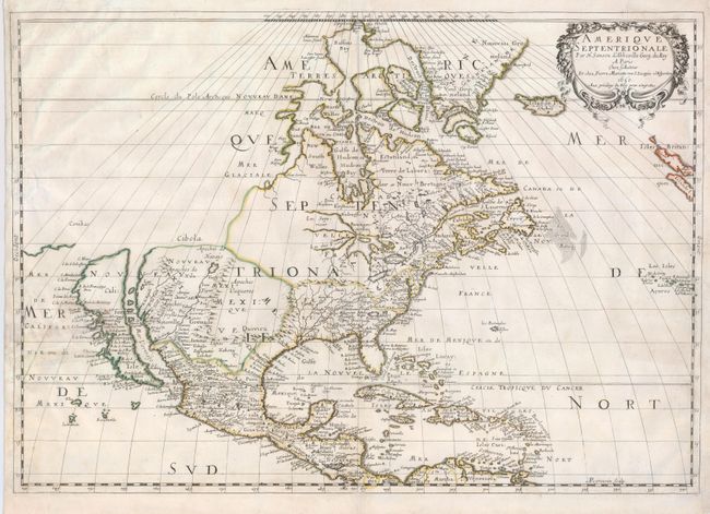
Sanson's important map of North America is the first to show all of the Great Lakes in a recognizable form, and the first to name lakes Superior and Ontario. The Arctic bears the cartography typical of this date, with Greenland shown as three islands, and another three-island mass in Baffin Bay. Buttons Bay is left open-ended to the west, allowing the hopeful possibility of a Northwest Passage. The map extends to include Iceland and Britain, as well as Central America and the Caribbean. On the east coast, Nouvelle Amsterdam (New York) is located on a very small and misplaced island. Delaware is noted as N. Suede, the first such place name on a printed map referring to the Swedish colony located there in 1638. The Southeast features two fictional lakes near the Carolinas, and Chesapeake Bay is greatly enlarged. Many Native tribes are identified in New Mexico where the R. del Norte (Rio Grande) mistakenly flows from an interior lake and empties into the Mar Vermeio (Gulf of California). This is the third state of the map with Lake Ontario properly shaded. Engraved by A. Peyrounin.
References: Burden #294; McLaughlin #12; Wheat (TMW) #47.
Condition: B
A nice impression on a sheet with original outline color. The margins are trimmed, but still sufficient for framing. The right and left sides of the map have some repairs, one into the left of the map about 2.5". Centerfold reinforced on the verso.