Subject: North America
Period: 1702 (published)
Publication: Atlas Nouveau, Contenant Toutes…
Color: Hand Color
Size:
23 x 18.3 inches
58.4 x 46.5 cm
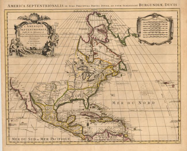
This is Pierre Mortier's striking, re-engraved version of Delisle's foundation map of North America. It is nearly identical to the Delisle map, with California returned to its peninsular shape rather than as an island. C. Mendocin is the farthest northern point in California, beyond which no conjectural geographical detail is presented. In the Southwest, a mountain-ringed valley named Valle de los Corozones appears, based on the early reports of Alvar Nuñez Cabeza de Vaca. Within the larger region of Nouveau Mexique lies a smaller region of the same name, centered on Acoma. The Great Lakes are well-defined, based on Coronelli with French forts noted. The English settlements are confined east of the Alleghenies, and the Spanish forts are clustered around Santa Fe. The Mississippi River valley area is well developed with recent French settlements. The first mention of what would be called the Sargasso Sea is noted in the North Atlantic. The map is decorated with an aquatic-themed figural cartouche and a draped scale of miles. Latin title across top: Amerique Septentrionalis in suas Preacipuas pastes Divisa, ad useum Serenissimi Burgundiae Ducis.
References: Tooley (Amer) #33, p.19.
Condition: B+
Lovely impression with original color. There is some faint, uneven toning in the map.