Catalog Archive
Auction 121, Lot 277

"Map of the City of New York", Dripps, Matthew

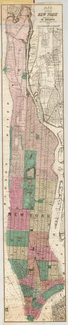
Subject: New York City

Period: 1868 (dated)

Publication:

Color: Hand Color

Size:
7.8 x 38.8 inches
19.8 x 98.6 cm
Download High Resolution Image
(or just click on image to launch the Zoom viewer)

A most uncommon map of the city showing railroads, schools, ferry lines and recent improvements in Central Park. The city grid goes north to 155th St., and is illustrated with the names of the original landowners, and the boundaries of their properties superimposed. Printed on fine banknote paper, and folds into the original red cloth covers with the title in gilt on front. A very nice example.

References:

Condition: A

A couple tiny fold intersection splits, otherwise fine. Covers are near fine with just a small water spot on inside cover.

Estimate: $350 - $450

Sold for: $550

Closed on 9/26/2007

Archived