Subject: World
Period: 1587 (dated)
Publication: Atlas Sive Cosmographicae Meditationes de Fabrica…
Color: Hand Color
Size:
20.5 x 11.3 inches
52.1 x 28.7 cm
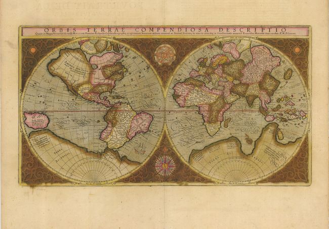
This beautiful double hemisphere map is surrounded in an elaborate strapwork border with an armillary sphere and a 32-point compass rose tucked between the hemispheres. Rumold Mercator based this map on his father's great world map of 1569. The North Pole is depicted as a landmass surrounding a sea from which four rivers radiate and there is a well depicted Northwest Passage. The huge Terra Australis is shown as a part of Tierra del Fuego, and the lands of Lucach, Maletur and Beach are noted along the coast in the vicinity of present day Australia from the travels of Marco Polo. A second Java (Iava Minor) is located at a considerable distance from the rest of the East Indies. Japan is shown in a kite-shaped configuration, with the fictitious Satyrorum insule (Satyr's Island) shown above. South America is shown with a bulge on its southwest coast, and New Guinea is depicted in a large, circular configuration. The map embodies many ancient authorities and is a wonderful view of classical cartography. Cracks in the copper plate are visible in the title, indicating a later publication circa 1620. French text on verso.
References: Shirley #157.
Condition: B
A wide-margined example with original color that has oxidized resulting in some verdigris cracks and a small amount of loss in the central cusp, now professionally stabilized and backed with archival tissue.