Subject: Wyoming - Yellowstone Park
Period: 1878 (dated)
Publication: HR Misc Doc. 47th Cong., 1st Session
Color:
Size:
28.5 x 32 inches
72.4 x 81.3 cm
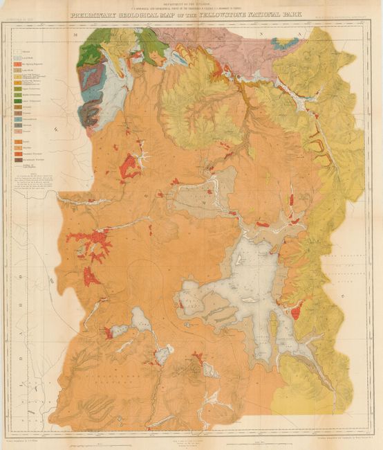
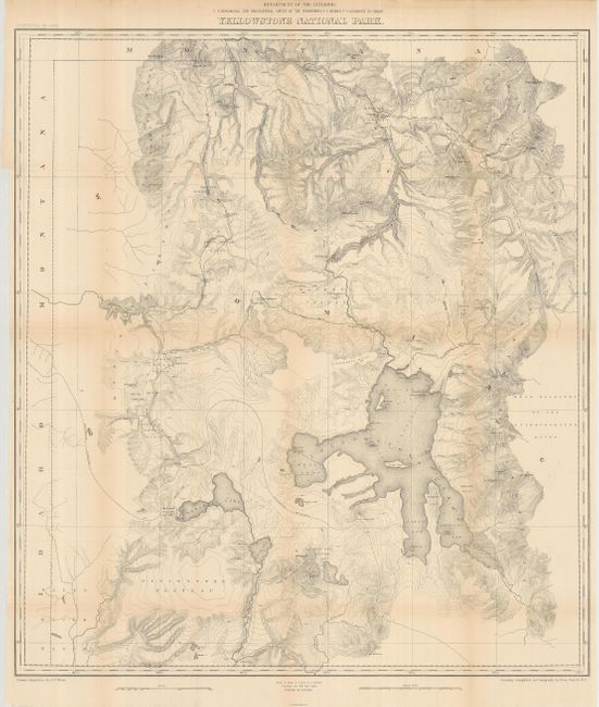
These two maps are the culmination of F.V. Hayden's monumental geological surveys to describe and illustrate the wonders of Yellowstone, the first national park. Although describing conditions surveyed in 1878, it was not published until 1883 in Hayden's 12th Annual Report. Wheat felt these two maps raised the cartography of Yellowstone to a "vastly higher level…and must be regarded as the first modern maps of the Park." The first is a spectacular, early chromolithograph map of Yellowstone printed in 18 colors by the notable firm of Julius Bien. W.H. Holmes was the Geological Assistant to Hayden. Although three or four reports had been written previously about the park, Holmes felt that there was still much more ground to be covered and said that he could have spent years, instead of the just the summer of 1878, to properly explore the geology of the park's 3,400 square miles. The chart is very detailed on a scale of 1 inch = 2 miles and filled with contour lines at 100 feet increments. The color key defines eighteen geologic formations. The latter is basically the same map, uncolored and without the former's geological information. Like the geological version, it shows the entire park from the Montana state line south to well beyond Yellowstone, Shoshone, Lewis and Heart Lakes, and from the border with Idaho east to the Yellowstone Range and the east fork of the Yellowstone River. Terrific detail of topography with contour intervals at 100 feet, watershed and numerous features are shown. Names the Upper, Shoshone, Gibbon, and Heart Lake Geyser Basins, Mud Geysers, Mammoth Hot Springs, and much more. Primary triangulation by A.D. Wilson and secondary triangulation and topography by Henry Gannett. An important pair of maps focusing on Yellowstone National Park.
References: Wheat (TMW) 1296.
Condition: B
Issued folding, both are now pressed and backed with archival tissue. The first has a little roughness at top margin and at binding trim. The second is very good with just some light folding toning.