Subject: Ohio River
Period: 1803 (published)
Publication: Journal of Andrew Ellicott
Color: Black & White
Size:
17.5 x 11.8 inches
44.5 x 30 cm
By the time of the Revolutionary War, the practice of awarding bounty land as an inducement for enlisting in the military had been a long-standing practice in colonial North America. Besides imperial bounty land grants, both colonial and municipal governments routinely compensated participants in and victims of military conflicts with land. Land was a commodity in generous supply, and governments seized upon its availability for accomplishing their goals.
Following this tradition, the Revolutionary governments used bounty land grants in their struggle for independence from Great Britain. They generally offered free lands in exchange for military service, provided they were victorious in their struggle. Thus, bounty lands were an effective technique for enrolling support for the war and encouraging re-enlistments. Generally the bounty lands were located on the western frontier, which provided another benefit to the government. Populating the frontier with citizens skilled in defense offered the best prospect in enticing other settlers to join them, thus eventually increasing the tax rolls.
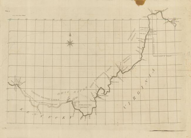
This map details the land districts surveyed by Andrew Ellicott along the Ohio River and into Pennsylvania's southwestern corner. Pennsylvania's western boundary or the so-called "Ellicott Line" became the baseline for the Northwest Territory. The map covers the river from Cincinnati to Pittsburgh, locating along the way numerous Bounty Land Grants, including the Virginia Military Lands, Chilicotha District, Ohio Company's Lands, Marietta District, and the Stubenville District. Also names Beaver Town, Stubenville, Buffaloe, West Liberty, Wheeling ("Weeling"), Marretta, Bellville, Point Pleasant, a large French settlement on the north shore, Limestone, and Newport. A portion of the river east of Cincinnati is drawn in skeleton form with Ellicott's notation "This is not from actual survey but is Supposed to be tolerably correct." This map is one of Ellicott's two Ohio River maps that were included in his Journal. Ellicott (1754-1820) was the leading geodetic surveyor in the early years of the United States. His desire was to produce accurate surveys and maps that compared favorably with those done by the best European surveyors. He is best known for the layout and survey of the new capital city of Washington. Ellicott became the Surveyor General of the United States in 1792. A scarce issue from America's first surveyor general.
References:
Condition: C+
On thick, hand laid paper with original margins. Long tear in blank areas of map from binding trim, and a long split at right along fold, both closed on verso with tape.