Subject: Illinois
Period: 1852 (dated)
Publication:
Color: Hand Color
Size:
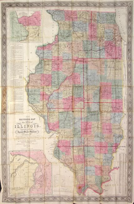
26.5 x 40.5 inches
67.3 x 102.9 cm
This very large and highly detailed pocket map, created by J.M. Peck, John Messenger, and A.J. Mathewson, contains a trove of information. Printed on fine banknote quality paper the map features two large insets: "Vicinity of Alton & St. Louis" and "Vicinity of Galena, the Lead Region and part of Wisconsin and Iowa." This example is surrounded by a lovely decorative border, and includes an extensive legend, distance scales, a table giving the populations of towns and villages, and a large table discussing Public Land and Land Districts. Paper label on inside front cover lists numerous maps available in both "mounted and pocket form" from the publisher. A very nice example of this early Colton pocket map. Folds into original green boards (3.7 x 5.8") with embossing and gilt title.
References: Philips (M) p. 329.
Condition: B+
Some very light stains or toning and a few fold intersection splits. Previous owners name stamped on back of map, not affecting image. Covers lightly rubbed with a small split on lower portion of spine. All in all, quite remarkable condition for its age.