Subject: Western United States
Period: 1879 (dated)
Publication:
Color: Printed Color
Size:
20 x 15 inches
50.8 x 38.1 cm
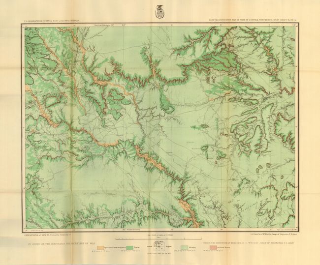
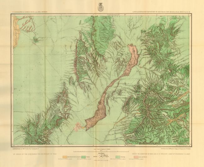
Wheeler's complete set of maps from 1879 in their original hardbound cover. This series of maps uses color to show land classification by Agriculture, Timber, and Grazing, as well as Arid or Barren. Together, the maps cover parts of California, Nevada, Idaho, Colorado and New Mexico. Each map is numbered on verso to match list on inside cover.
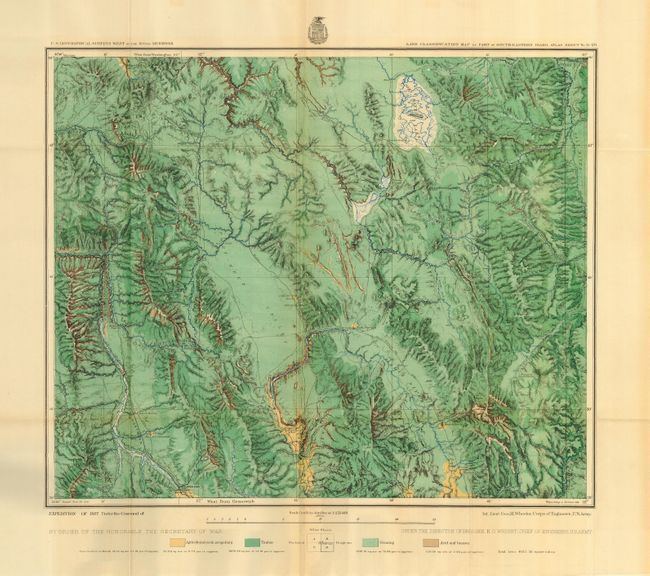
1) Land Classification Map of Part of South-Eastern Idaho, Atlas Sheet No. 32 (D). Centered on Soda Springs, the map locates the Mormon Salt Works, Georgetown, Bennington, Red Rock Pass, the Nine Mile Settlement and the Elkhorn Mail Station. The map includes portions of the Snake and Bear River drainage, the latter tributary to the Great Salt Lake Basin.
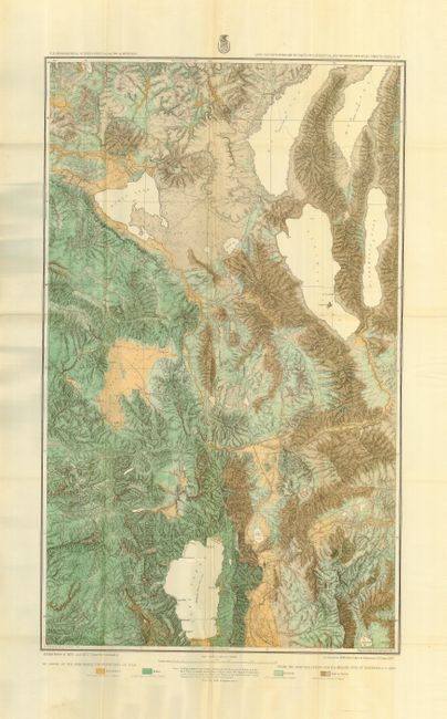
2) Land Classification Map of Parts of Eastern Cal. and Western Nev., Atlas Sheets 47 (B) & 47 (D). Great double page sheet that locates Reno, Carson, and Virginia City. Covers portions of the drainage basins of the Feather, Yuba, American, Truckee and Carson Rivers; Tahoe, Pyramid, Winnemucca and Honey Lakes and the so-called Mud Lakes; also the country in the vicinity of the Comstock Lode and that portion of the Sierra Nevada through which the Central Pacific Railroad passes. (Double sheet, 18.8 x 30.5")
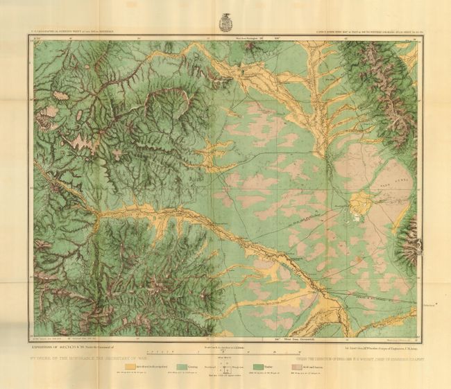
3) Land Classification Map of Part of South Western Colorado, Atlas Sheet No. 61 (D). Locates Del Norte and Saguache, gold mines, and the Denver and Rio Grande RR. Covers the region lying principally in the Rio Grande basins, including the greater portion of the San Luis Valley; shows also, present terminus of the Denver and Rio Grande Railroad at Alamosa.
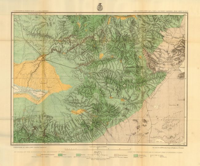
4) Land Classification Map of Part of Southern California Atlas Sheet No. 73 (A). Locates Bakersfield, stage stops, wagon roads and more. Includes a part of the Mohave Desert, belonging to the Interior Basin system and on the west a portion of the Great Valley system of California; showing Kern Lake and part of Kern River. These two basins are here separated by spurs and minor ranges, extending southward from the Sierra Nevada, crossed at the Tehachapai Pass by the Southern Pacific Railroad, which traverses the area from northwest to southeast.
5) Land Classification Map of Part of Central New Mexico Atlas Sheet No. 78 (A). Locates Las Vegas, numerous stage stops and wagon roads. The map details portions of the drainage of the Pecos and Canadian or Red Rivers, and delineating the great mesa system connecting the mountains extending from the northward with the plains of New Mexico; shows the present terminus of the Atchison, Topeka and Santa Fe Railroad in the vicinity of Las Vegas.
6) Land Classification Map of Part of Southern New Mexico Atlas Sheet No. 84 (B) Details the a portion of the drainage basins of the Pecos in the eastern and of the Rio Grande in the northwestern part; also the barren plains constituting the northern extension of the Jornada del Muerto, a peculiarly marked lava flow east of the San Andreas and Oscuro Mountains; several minor mountain ranges to the eastward and Fort Stanton.
All finely colored in green and ochre. Sizes vary slightly, but generally as given except the double sheet map as noted above. Hard covers in paper with leather spine with gilt stamped title. A very scarce collection detailing Wheeler's survey efforts from his expedition of 1877 and 1878, with some showing information from 1873 through 1876.
References:
Condition: A
The maps are very good to fine. Occasional toning on a fold visible on verso, but not on map side. Cover has just a little soiling and rubbing on spine.