Subject: World
Period: 1587 (dated)
Publication: Theatrum Orbis Terrarum
Color: Hand Color
Size:
19.25 x 14 inches
48.9 x 35.6 cm
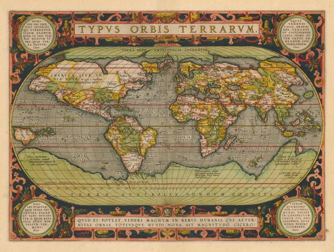
Ortelius' beautiful oval world map is a simplified version of Mercator's influential map of 1569. From surviving correspondence it is known that Mercator encouraged Ortelius and provided him with information, particularly with co-ordinates of places in the Americas. This is the first state of the Ortelius' third world map updated with the more correct shape of South America and the first depiction of the Solomon Islands off the coast of New Guinea. North America is nearly bisected by a lengthy St. Lawrence River, and the lands of Anian Regnum and Quivira are noted on the western coast. The Atlantic Ocean is filled with phantom islands, including Frieslant, St. Brandain, Brasil and many others. A huge Southern Continent incorporates Tierra del Fuego, and the mythical lands of Beach, Maletur and Lucach. The oval projection is surrounded by an intricate strapwork design and four corner medallions containing quotations from Cicero and Seneca. Latin text on verso, and an 'I', indicating a publishing date of 1592-1612.
References: Shirley #158; Van den Broecke #3.1.
Condition: A
Beautiful impression with wide original margins and lovely color. A few spots of foxing in the margins, and hinge remnants on verso.