Subject: Colonial New England and Mid-Atlantic
Period: 1636 (published)
Publication:
Color: Hand Color
Size:
19.5 x 15 inches
49.5 x 38.1 cm
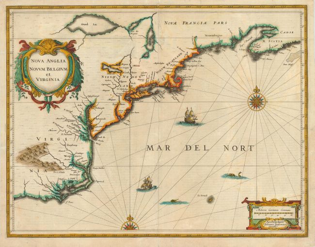
This is the first state of Jansson's influential map of the eastern coast of North America covering from just south of Cape Fear to Nova Scotia. The map is based on the less well-known map of Johannes de Laet of 1630, but covers a slightly larger area, and includes de Laet's fascinating description of the region and its resources in English on the verso. The map includes part of the Great Lakes, labeled Grand Lac and Lac des Yroquois, an unnamed Lake Champlain, and a fictitious lake at the headwaters of the Delaware River. According to Karpinski, this "is the first printed complete map of Lake Superior" although there is no evidence to support that and Grand Lac is more likely Lake Huron. The map is adorned with two decorative cartouches, ships, sea monsters and compass roses. A portion of the entertaining English narrative on the verso describes the edible denizens of the sea in verse, with the last phrase describing the shellfish particularly illuminating:
The Luscious Lobster, with the Crabfish raw.
The Brinish Oyster, Muscle Periwigge
And Tortoise Sought for by the Indian Squaw
Which to the flats dance many a winters Jigge,
To dive for Cocles, and to digge for Clammes,
Whereby her Lazie Husbands guttes she crammes.
References: Burden #247; Cumming (SE) #39; Karpinski, p. 26, p. 31, & plt. II; McCorkle #636.2.
Condition: B
Early impression and original color. A portion of the verdigris along the coastline of Virginia and around the bottom of Grand Lac has cracked. These cracks, the centerfold and side margins have old paper repairs on the verso. The map is sound and presents well.