Subject: Western Hemisphere
Period: 1785 (circa)
Publication: Geographie Moderne
Color: Hand Color
Size:
21.7 x 12.3 inches
55.1 x 31.2 cm
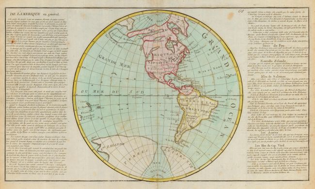
Unusual and attractive map of the Western Hemisphere with a dramatic Sea of the West prominently shown in the Pacific Northwest, along with an odd and amorphous Presqu-Isle du Nord Ouest, or Near Island of the Northwest, showing a small solid coastline that is noted underneath in French as being land seen by the Russians. This map is a compendium of actual discoveries blended with fantasy based on the Buache-Denis cartographic tradition referring to the Northwest Passage - but not actually showing the complete passage. New Zealand is shown as a part of Terres Antarctic, but only the coastline as surveyed by Tasman in 1642 is shown as solid, with the rest strongly hachured. A huge glacial sea at the pole bisects the Antarctic land mass. These uncommon cartographical oddities were replicated on the world map by Clouet of the same year as referenced in Tooley. Flanked by panels of French text, included in the total measurement.
References: Tooley [MCC-2] #80.
Condition: B
Sharply engraved map with original hand color. Some toning and scattered foxing and small hole in text portion of map.