Subject: Pacific Ocean
Period: 1700 (circa)
Publication: Le Neptune Francois
Color: Hand Color
Size:
29 x 23.4 inches
73.7 x 59.4 cm
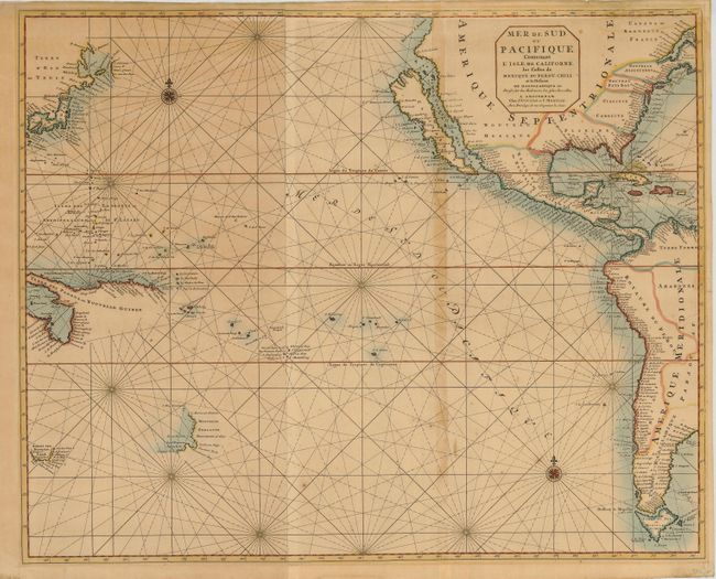
This uncommon and dramatic sea chart of the Pacific Ocean features an insular California using the information from Luke Foxe's map of the region with bays on the northern coast, an array of islands in the Mer Vermeio, and the large Agabela de Gato peninsula shown in the Pacific Northwest. The island of Japan is shown with an amorphous Hokkaido named Terre d'Eso ou Yedso from the de Vries expedition. Partial coastlines are mapped for New Zealand, Northern Australia, Tasmania and New Guinea. According to Koeman, Le Neptune Francois was the most expensive sea atlas published in Amsterdam during the 17th century. This map is from the expanded atlas with the Suite du Neptune Francois, a group of maps copied by Nicolas Fremont d'Ablancourt from manuscript maps collected by the Portuguese crown; a rare occurrence because Portugal was notorious for keeping their geographical sources secret. Printed on two joined sheets.
References: Koeman, Vol IV, pp. 423-24 & 430; McLaughlin #137; Tooley (Amer) p. 127, #64.
Condition: B
Sharp impression on strong paper with original coloring. The map is toned, a little darker along the paper joint and there is a little scattered foxing. The verso has an old paper repair and some tape residue and there are a couple short marginal tears, one just into the map at the right.