Subject: New York
Period: 1759 (dated)
Publication: Gentleman's Magazine,
Color: Black & White
Size:
4.5 x 7.4 inches
11.4 x 18.8 cm
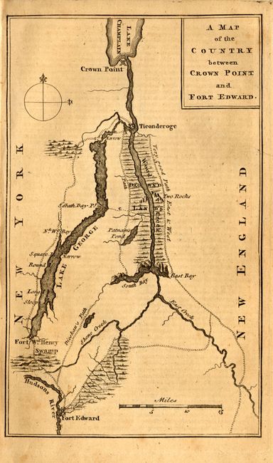
This map details the region in northern New York that was the theater of much of the French and Indian War. The map covers from Crown Point on Lake Champlain to Fort Edward on the Hudson and Fort William Henry on Lake George. Also shown are trails in the area and a large body of Drown'd Lands along Wood Creek to the south of Fort Ticonderoga. One of the trails is labeled Dieskau's Path referring to the route taken by French and Indian forces under the command of German Baron Ludwig August Dieskau and British and Colonial troops under Sir William Johnson that resulted in a series of skirmishes and engagements known collectively as The Battle of Lake George. This battle was the first significant win against the French forces by British Provincials. The map is still bound in with the Gentleman's Magazine of May, 1759 with the related article: Account of a late Expedition to Ticongerago.
References: Jolly GENT-129.
Condition: B
The map with some uneven toning, else fine. The binding is a bit loose with some detached sheets.