Subject: World
Period: 1708 (dated)
Publication:
Color: Hand Color
Size:
23 x 17.5 inches
58.4 x 44.5 cm
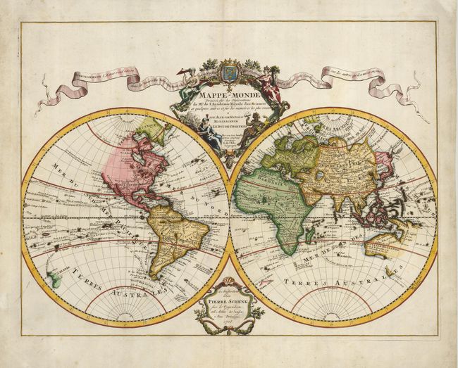
This handsome double hemisphere map is a corrected version of Delisle’s first world map, issued in 1700. The address notation in the lower cartouche removes Delisle's address in favor of Schenk's imprint. In this edition, new information corrects the representation of the Great Lakes, South America, and the Niger River in Africa. In keeping with Delisle's desire for accuracy, the northwestern portion of North America is not illustrated here and there is no evidence of Antarctica. Delisle used accounts from French explorers and colonizers of the Gulf of Mexico region. He also had access to accounts from survivors of La Salle’s expedition in the late 1680's. Despite his efforts to produce highly accurate maps, this map still shows several cartographic errors that were common during this period. It shows New Guinea connected to Australia, and it appears that Japan is connected to the mainland to the north with the nearby Terre de la Campagnie from the de Vries expedition. The map features an elaborate cartouche that includes four exotic female personifications of the continents. The banner across the top advertises Delisle’s upcoming book, Nouvelle Introduction à la Géographie.
References: Shirley #603.
Condition: B+
Lovely impression and original color that has been refreshed. A verdigris crack along the African coast has been professionally reinforced on the verso with cast paper.