Subject: United States - Southwestern
Period: 1850 (published)
Publication: HR Doc. 45, 31st Congress, 1st Session
Color: Black & White
Size:
27.5 x 14.7 inches
69.9 x 37.3 cm
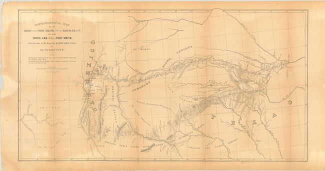
Excellent topographical map detailing, for the first time, the region along the Red River and the Canadian River. It shows two major roads from Fort Smith to Santa Fe, plus several other routes and Indian trails. The map also notes various tribal lands, topography and hydrology as well as the location of daily campsites. It is filled with interesting details and notations including the Apache Trail and Comanche Trail - "Said to be a good route for wagons, with water daily." It includes a very early depiction of Dallas located along the Trinity River. This map was published in the report on the Exploration of the Red River, made by order of Bvt. Brig. Gen. M. Arbuckle, by Capt. R.B. Marcy, 5th U.S. Infantry.
References: Wheat (TMW) #681.
Condition: B
Map is folding as issued with slightly uneven toning and a few short, marginal tears. One tear just enters the border at top, closed on verso with archival tape.