Subject: United States - Western
Period: 1883 (published)
Publication: H.R. Doc. 2, 37th Congress, 1st Session
Color: Printed Color
Size:
36.5 x 20.5 inches
92.7 x 52.1 cm
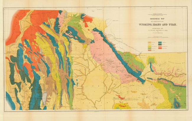
This map was one of six included in Hayden's 12th Annual Report published in 1883. It is a handsome and colorful map that largely covers part of Idaho eastward to the Sweetwater Range. Topography and Hydrology are nicely developed and an abundance of towns and villages are shown. Bear Lake is at lower left bordering Idaho and Utah, Rawlings is at lower right with a portion of the Union Pacific Railroad detailed. Locates wagon roads, trails, sand dunes, and has fine watershed details. Mining activity is clearly shown in place names like Miner's Delight, Camp Stambaugh, Atlantic City, etc. It locates Blackfoot, Rose Fork Agency (Fort Hall), John Gray's Lake, Caribou, the Wind River or Shoshone Reservation, and much more. Taylor's Bridge on the Snake River pre-dates Idaho Falls.
References:
Condition: A
Issued folding, now pressed and backed with archival tissue. Strong color and full, original margins. A little marginal toning on folds, short marginal split on one fold, supported by tissue backing. Re-margined at left to extend narrow margin at binding trim.