Subject: World
Period: 1705 (circa)
Publication:
Color: Hand Color
Size:
37 x 21.3 inches
94 x 54.1 cm
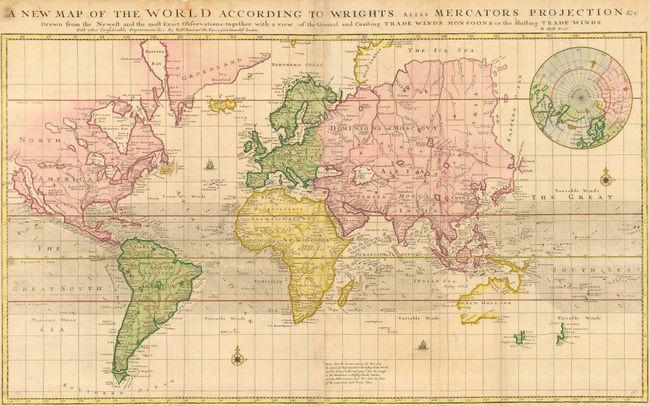
This is a large, uncommon and striking chart of the world presented on Mercator's Projection with a broad band through the middle depicting the trade winds. In North America, California is shown as an island with a very unusual configuration, shown with two northern bays and and a very pinched central area. Baron Lahontan's fictitous Riviere Longue is the most prominent feature in the West. While a very strange St. Lawrence River has its headwaters in Assinipovals Lake in the heart of Canada and then flows south through Nemipigon Lake and the Great Lakes before taking its normal course. Australia's coastline is partially shown with a suggested connection to New Guinea. A little bit of the coaslines of both Tasmania and New Zealand are noted as well. In Asia, Corea is not firmly connected to the mainland, the Land of Iesso and the Straits of the Vries are above Japan. There is a large inset of the North Pole. A couple compass roses and ships enliven the sea. Published by Mount and Page.
References:
Condition: B
Issued folding, now pressed. Sharp impression with original color and a couple light stains. The margins are narrow, but sufficient for framing with a couple of chips at top. Some remnants of framer's hinges on the verso.