Subject: North America
Period: 1830 (circa)
Publication: Geographie de Balbi
Color: Hand Color
Size:
12 x 8.8 inches
30.5 x 22.4 cm
In 1825 Haden Edwards received permission from the Mexican government to settle 800 families in East Texas. Edwards, a land speculator from Virginia, was known for his dishonest dealings with the settlers. After receiving many complaints the Mexican government revoked Edwards' grant in December 1826. Edwards and his brother, Benjamin, joined with local Indians (who felt Mexico had failed to deliver promised land) and settlers desiring to challenge Mexico's authority. They marched on the local capital of Nacogdoches on December 16, encouraged local residents to join them, and declared their independence from Mexico as the Republic of Fredonia.
In January, fighting erupted when settlers loyal to Mexico retaliated, further escalating with Mexican troops joined in fray. The Fredonians fled to Louisiana, and by the end of March 1827 the rebellion had been suppressed. The Republic of Fredonia, never recognized by any official entity, had lasted barely three months. The Mexican government then divided Edwards' grant and awarded it to other immigrants.
The Fredonia Rebellion was the third attempt at independence from Mexico. Texas Colonization became so popular with the Anglos that in 1830 Mexico reversed its position and barred further immigration. This action led the way to the "Battle of Nacogdoches," the opening skirmish in the Texas Revolution, which took place in August of 1832.
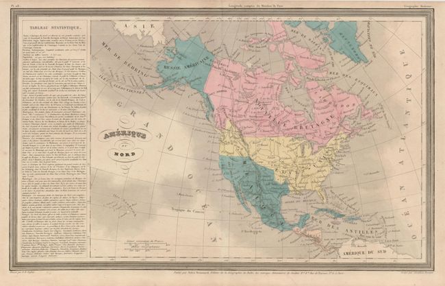
This finely engraved map features the region in Texas known as the Republic of Fredonia. The so-called Fredonia Rebellion was one of three conflicts leading to the independence of Texas. Fredonia was located in northeastern Texas, but is here depicted in the southern portion. Fredonia is rarely seen; in fact to our knowledge it is found on only a few published maps. This map locates the settlements of Nacogdoches and St. Antonio. In the Pacific Northwest, Oregon Territory extends well into Canada, an early indication of the Fifty-Four Forty or Fight dispute. Alaska is Russie Americaine. Panel of text ("Tableau Statistique") at left. A most desirable Texas item.
References:
Condition: B
The map has full margins, original hand coloring and crisp engraved lines. The map is very good to fine less a small hole at bottom center in a blank, un-engraved area near the centerfold.