Subject: North America
Period: 1669 (dated)
Publication: Carte generales de toutes les parties, du monde
Color: Hand Color
Size:
21.8 x 15.5 inches
55.4 x 39.4 cm
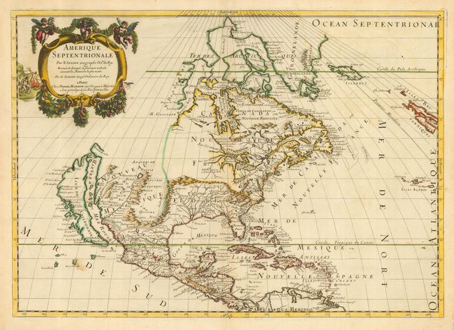
Handsome and important map by Guillaume Sanson, who in partnership with Pierre Mariette, based this map on his father's scarce 1666 wall-map of North America. This depiction replaced Nicolas Sanson's landmark map of 1650 in this atlas. Cartographically it is an amalgam of Sanson's maps of "Le Canada, ou Nouvelle France" and "Le Nouveau Mexique, et La Floride." The Arctic bears the confused cartography typical of this date, with Greenland shown as three islands, and another three island mass in Baffin Bay. The map extends to include Iceland, as well as a bit of Britain. Lake Erie is shown in a recognizable form and the entire Great Lakes network is shown in greater detail, although still with the western lakes open-ended. On the East coast, Long Island is shown near the R. de Nort, or Hudson River, and the shape of the Outer Banks is improved. Delaware is noted as N. Suede, the first such place name on a printed map referring to the Swedish colony located there in 1638. The island of California is now shown with an indented northern coast, in the form originating with Luke Foxe's map of 1635, and popularized by Sanson. Several Indian tribes are identified in New Mexico where the R. del Norte (Rio Grande) mistakenly flows from an interior lake and empties into the Mar Vermeio ou Mer Rouge (Gulf of California). First state of this map.
References: Burden #404; Tooley (Amer), p. 114; and McLaughlin #45.
Condition: B
Excellent impression with original color printed on fine paper with an elaborate watermark. A couple of small stains are all that keep this map from being perfect.