Subject: North Pacific Ocean and Western North America
Period: 1752 (published)
Publication: Delisle's Explication de la Carte des Nouvelles Discoveries
Color: Hand Color
Size:
25 x 17.7 inches
63.5 x 45 cm
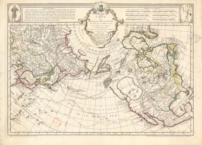
This is the scarce first state of this cornerstone map of Alaska and the Pacific Northwest. It depicts the discoveries of the Russians in 1723, 1732 and 1741, the tracks of Bering's first and second voyages, Joseph Nicolas Delisle's voyage with Capt. Tchirikow in 1741, the track of De Frondat's voyage of 1709, and the route of the Galleons in 1743. But more importantly it features the imaginary cartographic theories of Philippe Buache for the first time on a printed map. The west coast of North America is entirely fictitious north of Cap Blanc with an enormous Sea of the West, Lac Valasco, Isle of Bernarda. A network of rivers and lakes making up most of a Northwest Passage is derived from the apocryphal voyages of the Spanish admiral Bartholome de Fonte. Title in rococo cartouche flanked by a native of Kamchatka in upper left corner, a native of Louisiana in upper right corner. The map is accompanied by documentation of prior ownership.
References: Falk #1752-7; Hayes #41; Tooley (Am) p.34, #101; Schwartz & Ehrenberg plt. #94; Wagner (NW) #566.
Condition: B
Sharp impression with original outline color. There are two illegible ownership stamps in primarily blank areas. There are some stains on the eastern coast of North America.