Subject: Holy Land
Period: 1691 (dated)
Publication:
Color: Hand Color
Size:
33 x 20.8 inches
83.8 x 52.8 cm
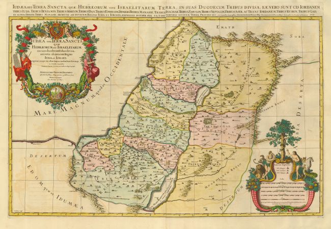
This spectacular map of the Holy Land shows the division of Judea into the Twelve Tribes of Israel. The map is based on the cartography of Guillaume and Nicholas Sanson and is from a series of greatly enlarged maps published by Jaillot in collaboration with the heirs of Sanson. It is filled with notations, topography and place names, including the locations of Gomorra, Sodoma, Seboim and Adama as flaming cities in the Dead Sea. There are a pair of extravagant cartouches adorning this map. The title cartouche is festooned with garlands, ribbons and fruit, and is surmounted by the French royal coat of arms and flanked by the figures of Moses and Aaron. At bottom is a minutely engraved medallion featuring Moses and the brazen serpent. The distance scale cartouche includes the key to the royal and priestly cities and sanctuaries. It is topped by a scene of Adam and Eve in the Garden of Eden, with the serpent and the Tree of Knowledge of Good and Evil. Printed on 2 joined sheets, as issued.
References: Laor #367.
Condition: B
Good impression and gorgeous old color. The map has some offsetting of color oxidation, but is still beautiful.