Subject: Holy Land
Period: 1570 (published)
Publication: Theatrum Orbis Terrarum
Color: Hand Color
Size:
18.5 x 14 inches
47 x 35.6 cm
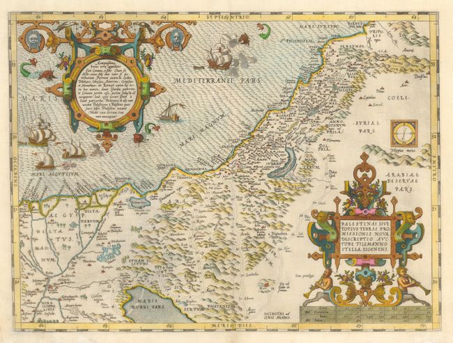
This is Ortelius' first map of the Holy Land. It covers the region from the Nile Delta to Lebanon, and focuses on the desert of the Exodus. Ortelius' map was based on Tilemanno Stella's map of 1557 that became the prototype for the modern cartography of the Holy Land. Stella adapted the coastline and Dead Sea from the configuration of Jacob Ziegler's map of 1532. But here, Ortelius rounds Stella's angular Dead Sea and the Gulf of Aqaba. The map is richly decorated with two elaborate, neoclassical cartouches. The unique square compass rose showing magnetic declination was also copied from Ziegler, but here is curiously shown up-side-down. The sea is teaming with five ships (three of which are shown with canons firing) and three sea monsters. This example is from the first of three plates used for the Theatrum. Latin text on verso.
References: Nebenzahl (HL) pp. 84-86; Laor #539; Tooley (TMC-3) p. 28; Van den Broecke #170.
Condition: B
Some paper damage repaired in bottom left corner and at centerfold.