Subject: Ancient World, France & England
Period: 1598 (dated)
Publication:
Color: Black & White
Size:
20.3 x 7.5 inches
51.6 x 19.1 cm
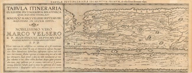
This is the first segment of the famous Peutinger Table, or a Roman road map of the world. The chart depicts the imperial roads and posts within the Roman Empire in France and England. The original parchment document was found in a library in Augsburg and came into the hands of Konrad Peutinger and later went to his relative Mark Welser who was the first to publish a copy of it in 1591 at Aldus Manutius in Venice. Ortelius then published a complete set in 1598, called the Peutinger Tables, which is how they became popularized. This map has been trimmed from the folio sheet, retaining the title cartouche and first segment. Latin text on verso.
References: Van den Broecke #227.
Condition: B
Lightly toned with narrow bottom margin. Tissue reinforced crease and remnants of framer's hinges on verso.