Catalog Archive
Auction 118, Lot 428

"Mappa Geographica Regionem Mexicanam et Floridam Terrasque adjacentes, ut et Anteriores Americae Insulas, Cursus itidem et Reditus Navigantium versus flumen Missisipi et alias Colonias…", Lotter, Tobias Conrad

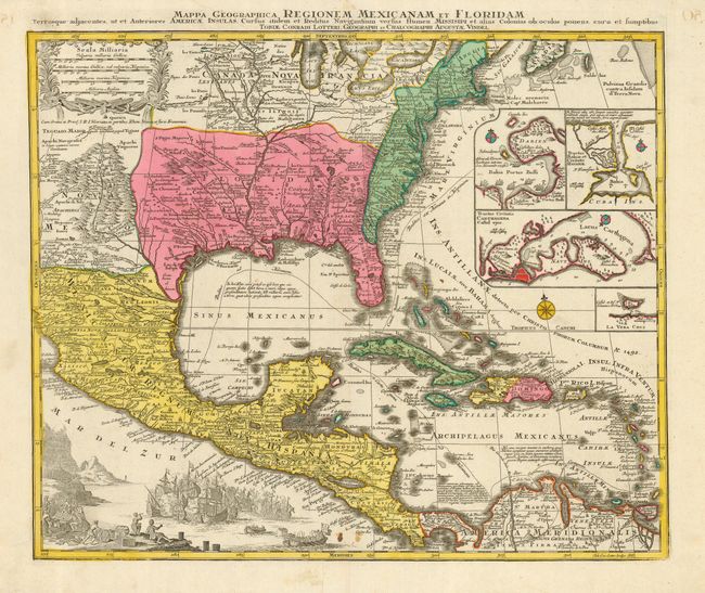
Subject: Colonial United States, Mexico & Caribbean

Period: 1740 (published)

Publication:

Color: Hand Color

Size:
22 x 18.5 inches
55.9 x 47 cm
Download High Resolution Image
(or just click on image to launch the Zoom viewer)

Tobias Lotter's decorative and beautifully engraved version of Delisle's important map of 1703 (Carte du Mexique et de la Floride). It provides a view of North America from the Great Lakes through the West Indies. The British colonies are confined east of the Appalachian Mountains, France controls the Mississippi valley and Florida, and Spain possesses Mexico; political divisions as dictated by the Treaty of Utrecht in 1713. The Southwest is finely described with many native tribes and pueblos noted, including Acoma, Santa Clara, Isleta and more. While geographically nearly identical to Delisle's chart, this map is very ornate with the lower left corner filled with a huge sea battle and the Atlantic filled with four inset plans of Panama, Havana, Cartagena and Vera Cruz.

References: Martin & Martin, plt. 18.

Condition: B

Original color. Small stain near the lower centerfold , else near fine.

Estimate: $1,500 - $1,800

Sold for: $1,500

Closed on 3/6/2007

Archived