Subject: Yonkers, New York
Period: 1855-71 (dated)
Publication:
Color: Hand Color
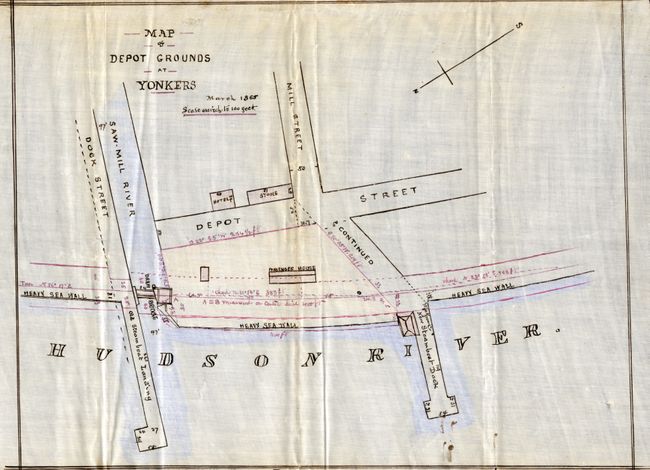
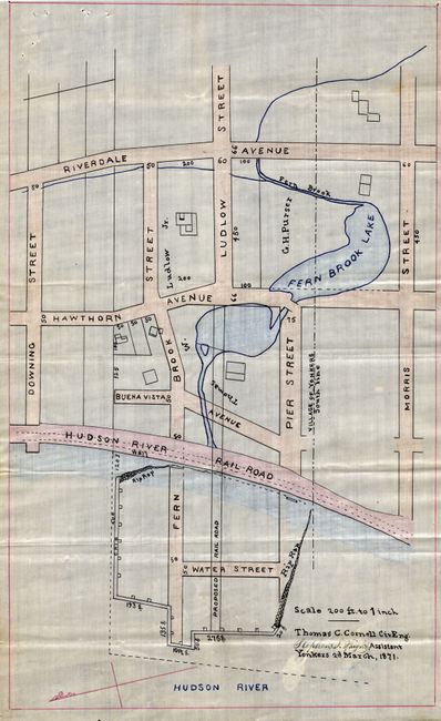
A great pair of manuscript maps with fine color drawn on coated linen. The cartographer employed pen and watercolor to produce these two maps. There is no attribution, but the maps appear to have been drawn for the Hudson River Railroad as there is much information on their lines. The first map has several notations, written in a different and less expert hand, that describe the line from a civil engineering point of view.
1) "Map of the Depot Grounds at Yonkers - March 1855 - Scale one inch to 100 feet." Depicts the Saw Mill River, passenger house, hotel, store, new steamboat dock, old steamboat landing, the Hudson River, and the streets of Dock, Depot, and Mill. (11 x 8.4")
2) Untitled map that shows a portion of Yonkers along the Hudson River. It is drawn on a "scale 200 ft. to 1 inch Thomas C. Cornell CivEng." The map is hand signed "Stephen S. Haight, Assistant Yonkers 2d. March, 1871." This map shows a portion of the town, but the focus appears to be the proposed railroad abutment into the Hudson River. Names the streets of Downing, Fern Brook (Ludlow today), Pier, Water, Morris and the avenues of Buena Vista, Hawthorn, and Riverdale. Locates the Hudson River Railroad running parallel to the river. This is the area of Oboyle Park. (7.5 x 12")
References:
Condition: A
Both are near fine, less a little surface soiling. The former has a few ink drops at lower right that are smudged. The latter with some pin holes at upper right.