Subject: United States
Period: 1846 (published)
Publication: 29th Cong. 1st Sess., Sen. Doc. 72, Serial 473
Color: Black & White
Size:
15.5 x 9.6 inches
39.4 x 24.4 cm
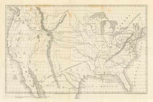
This unusual map of the United States shows the existing (finished and unfinished) railroads in the eastern states with a proposed railroad shown beginning at Prairie du Chin and stretching toward the Pacific through South Pass. There is also an unusual railroad stretching from Memphis to Guaymas with a connector reaching to Matagorda. This is named as Mill's Road. Robert Mills proposed linking the two coasts by rail as early as 1819 and was among the project's most ardent supporters. The map portrays the United States prior to the acquisition of California and the Southwest, with a large Oregon Territory and a large Texas. The map, engraved by O.H. Throop, was issued for Whitney's report to the 29th Congress in 1846.
Asa Whitney was one of the first backers of an American Transcontinental Railway. It was as early as 1830 that Whitney first became enthralled with railroads and foresaw their future role in business and transport. Whitney's proposed route from Lake Michigan through South Pass to the Pacific was not accepted mainly because of the growing sectionalism before the Civil War. However, the map is an important part of the railroad history of the United States.
References:
Condition: B
Sharp impression with folds as issued. There are just a couple light foxing spots in the map keeping this from being perfect.