Subject: Canada & United States
Period: 1814 (circa)
Publication: Thomson's New General Atlas
Color: Hand Color
Size:
24.5 x 16.1 inches
62.2 x 40.9 cm
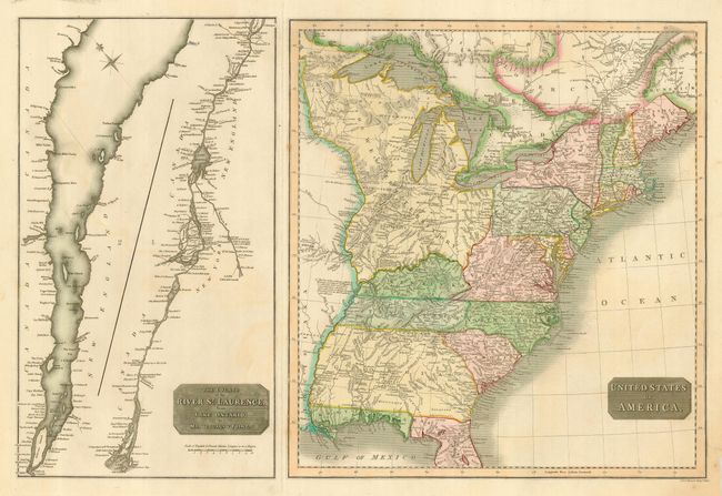
Two maps on one sheet. The left side is an uncolored chart of the St. Lawrence River in two parts. The entire course is shown from Lake Ontario to Montreal, Quebec and on to the mouth. Also shows a portion of Lake Champlain and the Richelieu River. The main map at right is a fully colored map of the United States extending to the Mississippi River. Maine is shown with British boundary claims. Georgia is shown with its western boundary extending all the way to the Mississippi River, and Florida is divided into East and West. The huge Western Territory is bounded by the Ohio River, Canada and the Mississippi. It includes today's Minnesota, Wisconsin, Michigan, Illinois, Indiana and Ohio. The map is filled with notations concerning the navigability of rivers and other items of interest. A handsome and interesting map that is worthy of further study.
References:
Condition: A
Great original coloring and fine impression. Small paper chip at lower right corner in margin well away from map image. A trace of offsetting in blank area of left panel, else fine.