Subject: South Pacific Ocean
Period: 1650 (circa)
Publication:
Color: Hand Color
Size:
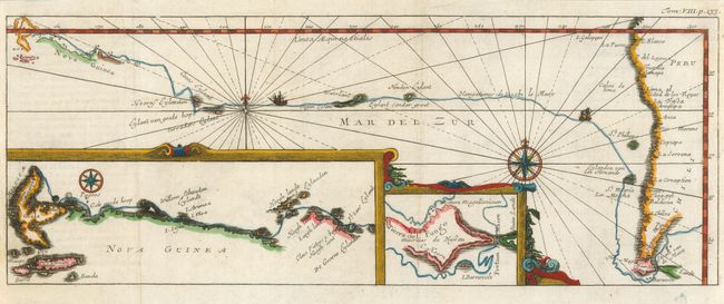
14 x 5.4 inches
35.6 x 13.7 cm
The map illustrates part of one of the greatest Dutch voyages of exploration. Undertaken in 1615 and lasting until 1617, this important expedition was the third complete circumnavigation, after Magellan. It was headed by Jacob Le Maire and Capt. Schouten under the auspices of a group of merchants headed by Jacob's father, Isaac. The expedition was the first to round Cape Horn from the east, naming the cape after the Dutch town of Hoorn, whose aggressive traders sponsored the voyage. In doing so they proved that Tierra del Fuego was not a part of Terra Australis or the great southern continent. In addition, the expedition explored the Pacific coast of South America and made numerous discoveries in the Pacific and along the coast of New Guinea. The map shows the route around Cape Horn, through the South Pacific to the famous Spice Islands of Indonesia. Two large insets provide details of Le Maire Strait and the northern coastline of New Guinea and the Spice Islands. Tom: VIII p. 133 in upper right margin.
References:
Condition: A
Some minor professional paper restoration in margins.