Subject: Nevada
Period: 1862 (dated)
Publication: HR Ex Doc 1, 37th Cong., 3rd Session
Color: Hand Color
Size:
20 x 29.8 inches
50.8 x 75.7 cm
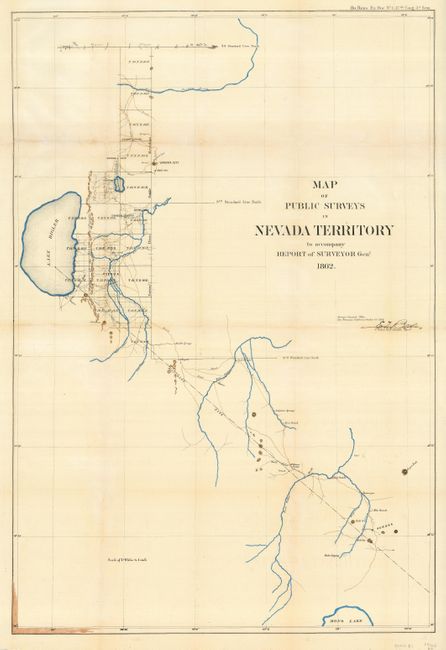
This is one of the earliest General Land Office maps of Nevada. From 1850 to 1861 the Utah territorial government exercised control over the area of today's Nevada. The discovery of the Comstock Lode in June 1860 and the outbreak of the Civil War led to the establishment of the Nevada Territory on March 2, 1861. This map graphically illustrates the scanty knowledge of the area at the time. As is typical for the time, Lake Tahoe is misshapen and here called Lake Bigler. The map names Carson City, Virginia City, Genoa, 5 Mile Ranch, Nye's Ranch, and more. Drawn on a scale of 4 miles per inch, it was made in the San Francisco office of the General Land Office and is signed in the plate by E.F. Beale. Beale [1822-1893] had a long and varied career in the West including Indian Agent, surveyor, camel driver and western wagon road builder. When this map was made he was the Surveyor General to California and Nevada. A year earlier he requested a Union Army command, but Lincoln persuaded him to remain as surveyor general and to help keep California in the Union.
References:
Condition: B
Issued folding, now pressed flat. Some fold toning and a few fold splits closed on verso with archival tape. Modern coloring that has bled through to the verso.