Subject: Florida
Period: 1840 (dated)
Publication: 26th Cong. 2nd Sess. Senate doc. No. 9
Color: Hand Color
Size:
22.5 x 9.3 inches
57.2 x 23.6 cm
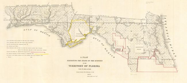
This early, interesting map shows the status of public land surveys in the Eastern and Western Land Districts of the Florida Panhandle. Yellow outlines the boundary of the Forbes Purchase in this edition. St. Augustine, Ameilia Island, and Tallahassee are named. An area outlined in red is designated "Supposed Indian Boundary Line" while the legend indicates that red outlining is used to indicate proposed new survey areas. Survey efforts in south Florida continue to be hampered by the guerilla warfare of the Second Seminole War (1837-1842). From the Surveyors Office in Tallahassee by Robert Butler Survey General Territory of Florida. This lot is a great comparison to the previous lot, issued 3 years earlier, as it shows the considerable progress of the surveys.
References:
Condition: A
Folding, as issued. A near fine example.