Subject: Florida
Period: 1837 (dated)
Publication: 25th Cong 2nd Session Doc. No. 11
Color: Hand Color
Size:
23.5 x 8.6 inches
59.7 x 21.8 cm
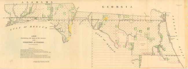
This map is one of the earliest to illustrate the status of public land surveys in the Eastern Land District (east of the Suwanee River) and the Western Land District (west of the Suwanee) in the Florida Panhandle. Survey efforts south of the Indian Boundary Line (marked in red) in southern Florida were largely suspended due to the guerilla warfare of the ongoing Second Seminole War. St. Augustine, Amelia Island, and Tallahassee are named. In this early edition, the "Supposed boundary of the Forbes Purchase" is uncolored and the legend notes its limits are undefined. From the Surveyors Office in Tallahassee by Robert Butler Surveyor General Territory of Florida. A very early edition of this chart.
References:
Condition: A
Folding, as issued. Close trimmed at lower right, as issued. Toned a little along binding side in area of stitching, well away from image.