Subject: Midwestern United States
Period: 1891 (dated)
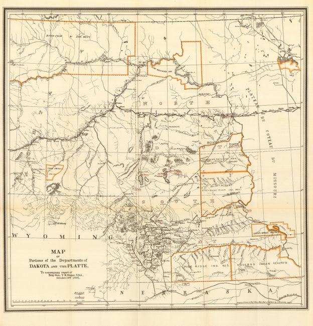
Publication: Report of Brig. Gen. T.H. Ruger
Color: Printed Color
Size:
20 x 20 inches
50.8 x 50.8 cm
A highly detailed map of the region that extends from Devil's Lake at upper right, west to the Four Buttes in the River - Crow Reservation and south of Hill City. The map is highly detailed and is filled with information including hundreds of place names, wagon roads, towns and settlements, numerous forts and camps, and extensive detail of the watershed. The Standing Rock Agency, Cheyenne River, Pine Ridge, Rosebud, North Cheyenne, Fort Berthold, and Lower Brule Indian Reservations are identified. The railroad network is extensively covered. Just 10 months before the publication of this map, General Ruger ordered the capture of Chief Sitting Bull during the campaign to suppress the Ghost Dance movement. The action resulted in the death of the infamous chief and the entire Wounded Knee fiasco. The map notes the location of Sitting Bull's camp along the Grand River in the Standing Rock Ind. Res. All military forts and positions are underlined in overprinted red. A seldom seen map that was prepared in the Engr. Office Hdqrs. Dept. of California by C. Winstanley.
References:
Condition: A+
Folding as issued with original margins.