Catalog Archive
Auction 116, Lot 188

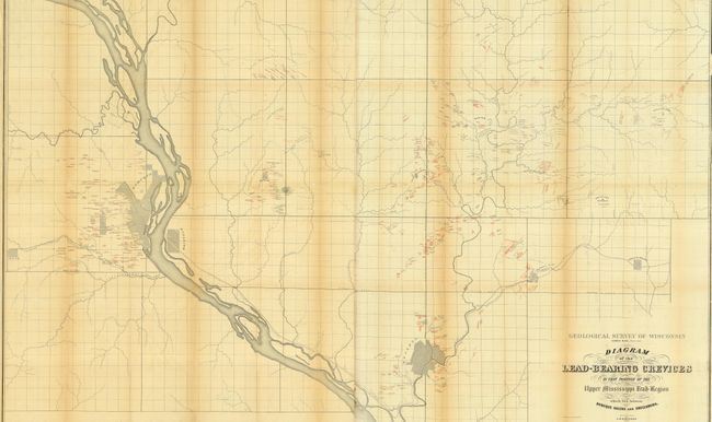
"Diagram of the Lead Bearing Crevices in that portion of the Upper Mississippi Lead Region which lies between Dubuque Galena and Shullsburg. Surveyed and drawn by J D Whitney", Hall, James

Subject: Midwestern United States

Period: 1860 (dated)

Publication: Geological Survey of Wisconsin…

Color: Printed Color

Size:
60 x 38 inches
152.4 x 96.5 cm
Download High Resolution Image
(or just click on image to launch the Zoom viewer)

Large, detailed chart that shows the location of hundreds of lead deposits and workings with red over-printing on the black and white map. Some of the diggings have unusual names: Buzzard's Roost, Smuggler's Ridge, Dry Bone, Piggs Patch, and many more. The map includes town plans for Galena, Dunleith and Dubuque, and delineates the route of the Illinois Central, Dubuque and Pacific railroads, plus an unnamed track that runs between Galena and Scales Mound. It names the villages of Scales Mound, Council Hill, Fairplay, White Oak Springs, Benton and Julien. This seldom seen map is printed on two sheets, joined as issued.

References:

Condition: B

Issued folding, now pressed and backed with archival tissue. One area along a fold that has lifted from tissue backing, toned along folds.

Estimate: $150 - $180

Sold for: $100

Closed on 9/20/2006

Archived