Subject: World
Period: 1630 (dated)
Publication:
Color: Hand Color
Size:
21.5 x 15 inches
54.6 x 38.1 cm
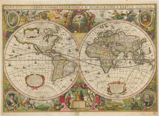
This baroque-style world map features hemispheres surrounded by representations of the four elements: Fire by Apollo driving the Sun's chariot across the sky; Aeros, the goddess of Air, surrounded by clouds and birds; Demeter, surrounded by animals and the earth's bounty; and Water represented by a Siren and sea monsters. Tucked between the hemispheres are a celestial globe with the figure of the sun at top, and a scene of Europa receiving tribute from Asia, America and Africa with a figure of the moon at bottom. Four portraits fill the corners: Julius Caesar, Claudius Ptolemy, Jodocus Hondius and Gerard Mercator. The scenes are all beautifully linked together with a rich garland of fruit. For geographical detail, Hondius presented California as an island, the Dutch discoveries on the Carpentaria coast of Australia, and Queen Anne's forland (Baffin's Island) on the northeast coast of Canada. The faint outline of Terra Australis Incognita is still in evidence. French text on verso. This map had a long life and was included in all issues of the Mercator/Hondius atlas from 1633 onwards. This is the first state issued prior to 1641.
References: Shirley #336.
Condition: B
Good impression and lovely old color. Extensive repairs along centerfold including some infilling and a few lines of facsimile in central scene at bottom. Some surface soil and minor spots.