Subject: Eastern United States
Period: 1818 (dated)
Publication:
Color: Hand Color
Size:
19.8 x 16 inches
50.3 x 40.6 cm
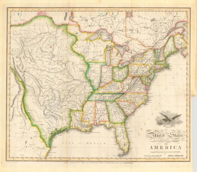
A very early example of this important map by the noted American cartographer John Melish. This first edition example extends west to the Rocky Mountains and provides a detailed view of the Missouri River based on information from the expeditions of Lewis & Clark, Pike, Humboldt and others. A notation at the western edge of the map shows where "Clarks Canoes stop 3000 miles from the Mississippi." The huge Missouri Territory takes in the entire region from the Mississippi and Red Rivers to the Rocky Mountains and incorporates Texas. The only state shown west of the Mississippi is Louisiana. Today's Minnesota and Wisconsin are here a part of North West Territory. In Texas there are a few place names including Ft. Matagorda, but Galveston is poorly located. Illinois is depicted too far west with a cantilevered section stretching to Chicago and Lake Michigan. Good detail throughout includes towns and villages, Indian place names, roads and trails, forts and watershed. Above the script title is a vignette of an eagle emblazoned with the stars and stripes. The genesis for this map is with Melish's 1812 pocket map. This is the very desirable, early and separately issued edition dated 10th July 1818 and published by Murray Draper Fairman & Co. in Philadelphia. Engraved by Samuel Harrison.
References: Wheat (TMW) #327.
Condition: B
Very fine original coloring and crisp impression. Issued folding, now flat with some creasing along two folds, one with some minor, repaired cracking near Florida. A few unobtrusive spots in map.