Subject: United States
Period: 1849 (dated)
Publication: Mitchell's School and Family Geography
Color: Hand Color
Size:
16.8 x 10.3 inches
42.7 x 26.2 cm
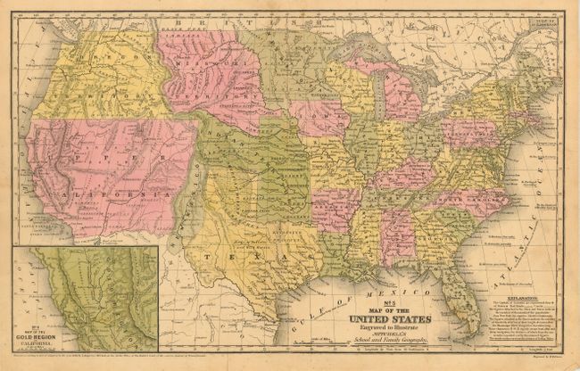
This map has terrific western territorial borders including the important territorial acquisitions of the Mexican-American War. The inset map "No. 6 Map of the Gold Region of California" is a very early depiction of the Gold Regions that names Sutter's Buttes, Sacramento City, and all of the important creeks of the gold region feeding into the Sacramento and Feather rivers. Upper California occupies the entire Southwest, with just a narrow strip along the Rio Grande identified as New Mexico. This edition features Texas with a broad panhandle. Oregon Territory extends from the 42nd parallel to the recently established border with British America and east to Missouri Territory at the Continental Divide. Minnesota Territory includes the Dakotas. A huge Indian Territory stretches from Texas to Missouri Territory along the North Fork of the Platte River and extends westward all the way to South Pass.
References:
Condition: B
Great impression and fine original hand coloring. A little light scattered foxing mostly in lower blank areas, short clean split at lower fold, else very good.