Subject: Southeast Asia
Period: 1563 (circa)
Publication: Delle navigationi et viaggi
Color: Black & White
Size:
14 x 10.7 inches
35.6 x 27.2 cm
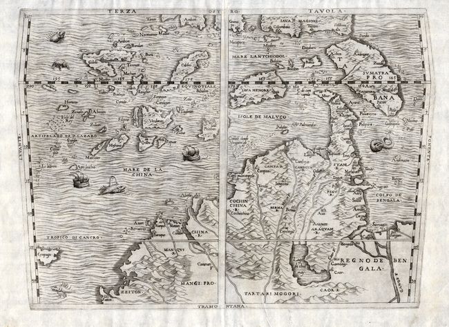
This fascinating map is one of the foundation maps in the cartography of Southeast Asia. It is oriented with south at the top and covers the region from the Ganges to the north coast of Java and Timor and through the Philippines, Japan and much of China. The map was drawn by Giacomo Gastaldi, who dominated cartography of this region throughout the middle decades of the sixteenth century. The map draws on information compiled from Magellan's voyage and the marine charts of the Portuguese. Japan is shown as a small island labeled Cympagu. The mythical Lago de chiamay dominates the mainland interior and forms the source of four rivers. A large island appears at the tip of the Malasian Peninsula and is labeled Muar and C. de cincapula. The map is embellished with a variety of sea monsters and two sailing ships. This is the second state, engraved on copper, after the woodblock of 1554 was destroyed by fire.
References: Karrow #30/75; Suarez (SEA) pp. 130-157, fig. 74.
Condition: A
Fine impression. Minor professional repair on top centerfold.