Subject: Russia
Period: 1659 (circa)
Publication:
Color: Hand Color
Size:
22 x 18.5 inches
55.9 x 47 cm
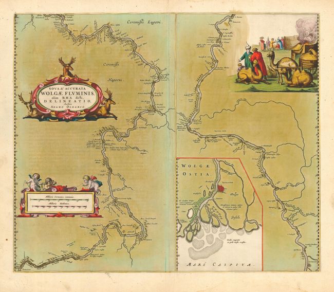
Beautifully engraved map shows the Volga River in two parts based on the travels of Adam Olearius. The left side of the map charts the river between Nazhniy Novgorod and Saratov, the right side continues to Astrachan. The river's mouth on the Caspian Sea is shown in a large and detailed inset. The map is richly embellished with a title cartouche showing three reindeer, plus a large vignette at upper right featuring an encampment with tribesmen and camels, and a distance scale cartouche with three chubby putti. French text on verso.
Adam Olearius was a German scholar, mathematician, geographer and librarian. He was sent in 1633 by Duke Frederick III to Moscow and Persia to seek treaties favoring the newly-founded city of Friedrichstadt as the terminus for an overland silk road. The party traveled from Hamburg to Moscow via Lubeck, Riga, Dorpat, Revel, Narva, Ladoga and Novgorod. A favorable treaty was struck with Michael Romanov in 1635. Later that year Olearius returned to Moscow and then on to Persia via the Volga and the Caspian Sea. After an arduous journey he meet the shah in August 1637, but negotiations were not successful. On the return trip, Olearius left his party at Revel heading directly for Lubeck. He mapped the Volga along the way, bringing this knowledge to Europe.
References:
Condition: B
Dark, crisp impression with full original hand coloring and wide margins. Some oxidation and offsetting and a soft crease along side centerfold.