Subject: Southwestern United States
Period: 1860 (published)
Publication: HR Doc 42, 36th Cong. 1st Sess.
Color: Black & White
Size:
48.5 x 7 inches
123.2 x 17.8 cm
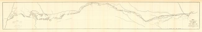
Beale [1822-1893] had a long career in the West including Indian Agent, surveyor and camel driver. His most lasting contribution was as a wagon road builder. This map resulted from the survey of a road across present-day Oklahoma, Texas and New Mexico and originally appeared in Beale's "Construction of a Wagon Road from Fort Smith to the Colorado River." His route roughly follows the Canadian River and closely parallels or is identical to the trail of Lt. Whipple just a few years earlier. A dotted line indicates where the routes diverge. The map names Van Buren, Fort Smith, Santa Fe, and Albuquerque. Beale's 62 daily campsites are shown.
References: Wheat [TMW] #939; Koepp #1048.
Condition: A
Folding as issued. A near fine example of this map with only very light toning in upper margin.