Subject: Western United States
Period: 1884 (dated)
Publication: Report on the Internal Commerce of the United States
Color: Printed Color
Size:
24.5 x 24 inches
62.2 x 61 cm
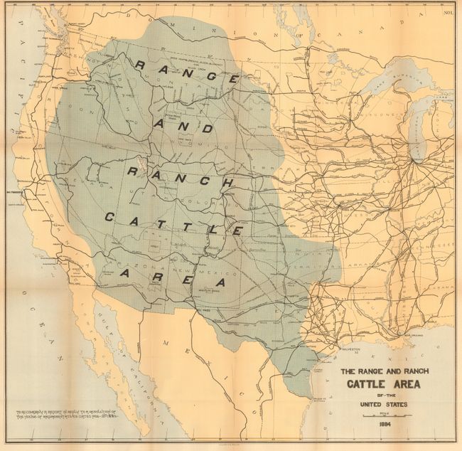
A fascinating map that shows the trans-Mississippi West, extending east to beyond Chicago and Lake Michigan. It delineates the ranch and range areas, through shading, to include western Texas, Indian Territory, New Mexico, Arizona, and Nevada, and north to include all of Utah, Colorado, Wyoming, Montana and parts of the adjacent states. Joseph Nimmo issued this important report on the cattle industry at the height of cattle ranch speculation. The map locates the Ft. Griffin and Dodge City Trail shown between Bandera, Texas and Ogalala, Nebraska. The 'assumed' northern limit of the Texas Fever District is noted, as are the Colorado and the Kansas quarantine lines. A Proposed Cattle Trail leaves the Ft. Griffin and the Dodge City Trail in northern Indian Territory, heads west and north into eastern Colorado and north to the Canadian border via Nebraska, Dakota, and Montana. Other details include extensive railroad lines, isothermal lines, Indian Reservations, and more. The map was not present in all editions of the report, making this a rather rare issue.
References:
Condition: A
Folding, as issued. Trace of toning that is barely visible, two tiny fold intersection splits, still very good example.